“Twister” came out in 1996. David Roueche may be the only assistant professor of structural engineering specializing in extreme wind loads on low-rise buildings, post-tornado disaster field investigations, performance-based wind engineering and wind resistance of light wood-frame structures in the world who still hasn’t seen it.
He tries to keep quiet about it.
The movie is kind of a cult classic among his colleagues, inspiring a generation of meteorologists and storm chasers and weather nerds and such. So, when it comes up he’ll just smile and nod along. When it comes on TBS and the scientists and engineers he interacts with on Twitter have their online watch parties and start sharing memes with the cow flying through the air, he’ll click the heart button. Whenever they share little clips, he’ll sometimes hit play. It’s been plenty enough for him to get the gist over the years — enough for him to start nodding before you even finish asking if the real science in the script parallels the research he’ll begin late this summer, at least in terms of an ultimate goal.
“Yes, basically,” he said. “With both, you’re trying to understand the behavior of tornadoes. You’re trying to accurately determine a tornado’s wind speed rather than just estimate it from the damage it’s caused.”
Bill Paxton and Helen Hunt did it with a big bucket of spherical sensors — Dorothy, they called it. If you got Dorothy in just the right spot, the idea was that a tornado would suck the sensors into its funnel and transmit in 30 seconds more statistical insight into what makes twisters tick than weather scientists had acquired in 30 years. It was based on an actual instrument that National Oceanic and Atmospheric Administration and National Severe Storms Laboratory researchers developed in the 1980s, the TOtable Tornado Observatory (TOTO).
TOTO didn’t work.
Roueche thinks his new approach just might.
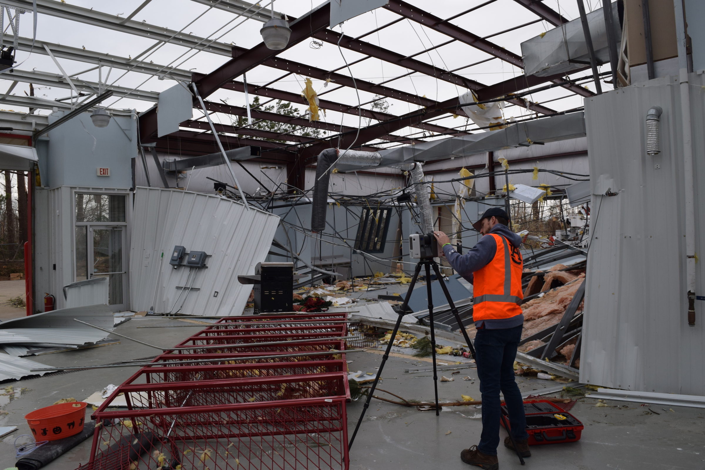
Digitizing Debris
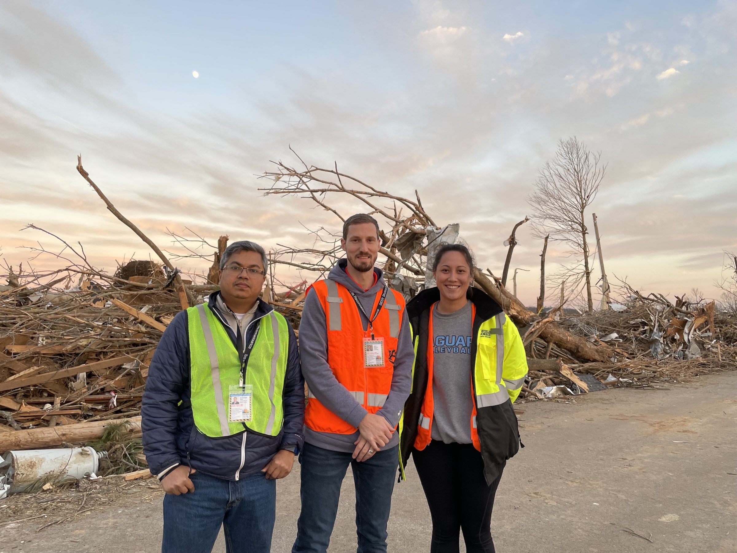
He’s already an expert in analyzing the aftermath; where there’s rubble, there’s Roueche — taking photos, taking measurements, taking stock. What could have kept that wall from crumbling? What could have kept that manufactured home on the ground? Why was this 10-year-old site-built home torn apart while the 20-year-old home next to it only lost a few shingles? Which building codes were violated? Which foundations did what they were supposed to do? Combined with an active social media presence, his rapid, boots-on-the-ground approach to research — mounting a 360-degree camera system to his car and immediately deploying to disaster areas — has turned the field work aficionado into a go-to source for outlets like the Washington Post and NPR looking to shine a spotlight on headline-making southern storms. He was tapped to be associate director of data resources for the National Science Foundation’s (NSF) Structural Extreme Events Reconnaissance Network (StEER) for a reason.
In 2020, he received a $573,297 NSF Early Career award to develop better methodologies for utilizing post-windstorm reconnaissance in enhancing resilience.
But, apparently, the aftermath — the “post” part of “post-windstorm” — can only tell us so much.
As it turns out, in terms of wind speed, those Fujita scale ratings you hear about — EF3 and EF4 — are, technically, just guess work, Roueche said, based mostly on damage assessment that also leaves plenty of other crucial questions unanswered. Were the winds straight line? Were they horizontal? Were there vertical components? Were there updrafts?
“A lot of people don’t realize that we really don’t know a lot of what characterizes wind speeds in tornadoes, at least near-surface where our buildings are,” Roueche said. “We have instrumentation on towers, we have anemometers set up at airports and in different locations, but tornadoes rarely pass directly over them, and when they do they typically damage the instrumentation. So, we don’t have a way of reliably measuring wind speeds in tornadoes.”
Yet.
It’s kind of a simple idea, one that Roueche thinks should be able to happen easily enough in 2022. The technology is there. Social media is there. Now the funding is there.
In October 2021, the NSF awarded Roueche and research partners Franklin T. Lombardo, a structural engineering professor at University of Illinois Urbana-Champaign, and Mani Golparvar, an associate civil engineering professor specializing in computer science and technology entrepreneurship also at the University of Illinois Urbana-Champaign, nearly $400,000 toward the 4D Wind Field Reconstruction of Near Surface Wind Environment and Other Convective Storms project.
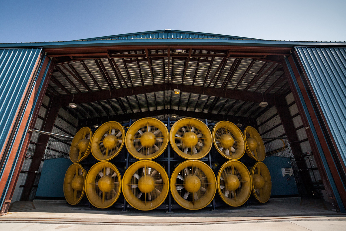
That should be enough to pay for the time in Florida International University’s Wall of Wind, to pay for all the Ring doorbells and GoPros and iPhones and security cameras they’ll set up to record what happens to the nails and 2x4s and windows and rocks and dishes and staplers and Teddy bears and photo albums (and any other real-world debris they can find) when they turn the knobs of the largest and most powerful university wind research facility of its kind up to 100 and 130 and 150 miles per hour.
The goal? AI for tornado research; instead of facial recognition, wind-speed recognition.
Build an algorithm. Train it with gigabytes of video recorded under known conditions. Develop a debris pattern database that computer vision can compare to crowd-sourced footage of tornadoes. Mix in the latest, state-of-the-art debris-flight models. Save lives.
“Our buildings are not as strong as they should be and they’re failing much sooner than they should,” Roueche said, “and one reason is that there’s just a dearth of actual measurements of what happens inside a tornado.”
What there isn’t, though, is a dearth of footage of what happens in and around tornadoes.
“There’s now a wealth of sources that capture tornadoes,” Roueche said. “There are cameras everywhere. So, the basic idea of the project is to use the footage we record to build a way to parse all of the tornado video we can source in order to extract useful information from it that can help us design safer buildings.”
Life-Changing
David Roueche did not grow up in a safe building, structurally speaking. His family lived in a manufactured home in Jacksonville, Florida. They had to stay on their toes come hurricane season. Do they drive to Grandmama’s brick house further inland? Shelter in a church? Stay put?
But extreme wind events actually have a habit of skipping Jacksonville. Hurricanes typically bounce off Florida’s northeast coast. Tornadoes are few and far between.
“I was first exposed to what tornadoes can really do when I went to Tuscaloosa,” Roueche said.
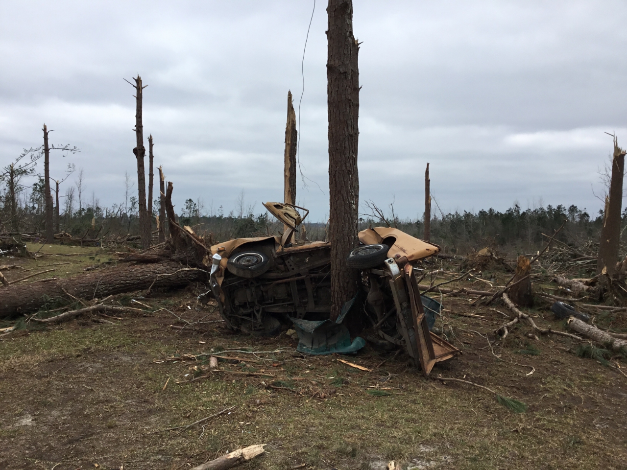
It was 2011, the day after he received his civil engineering degree from the University of Florida. His professor, David Prevatt, a well-known researcher in structural resilience, encouraged him to join his team on a trip. Days earlier, on April 27, an EF4 tornado — that at one point was 1.5 miles wide — leveled portions of Tuscaloosa. Prevatt’s team planned to drive the 15 hours to assess the damage. Roueche said yes.
It changed his life.
“I still vividly remember those images,” Roueche said. “That’s what really ignited my passion to pursue this avenue of structural engineering, which, of course, Auburn has been perfect for, not only in the terms of the resources we have here, especially now with the new Advanced Structural Engineering Lab, but, geographically, we’re strategically positioned kind of in the heart of what they call Dixie’s tornado alley.”
Alabama is a tied with Oklahoma, which has 17,480 more square miles, for the state with the most confirmed EF5 tornadoes. It frequently leads the nation in annual tornado fatalities.
In 2019, it wasn’t close.
Close to Home
It was the morning of March 3, 2019. It was easy for Roueche to be one of the first engineers on the scene, along with associate professor Robbie Barnes, his colleague in Auburn’s Department of Civil and Environmental Engineering. Beauregard was just 10 minutes from his home in Opelika. Roueche had been hunkering down with family like the rest of Lee County, watching the news, watching Twitter, tracking the storm on his phone with a specialized app.
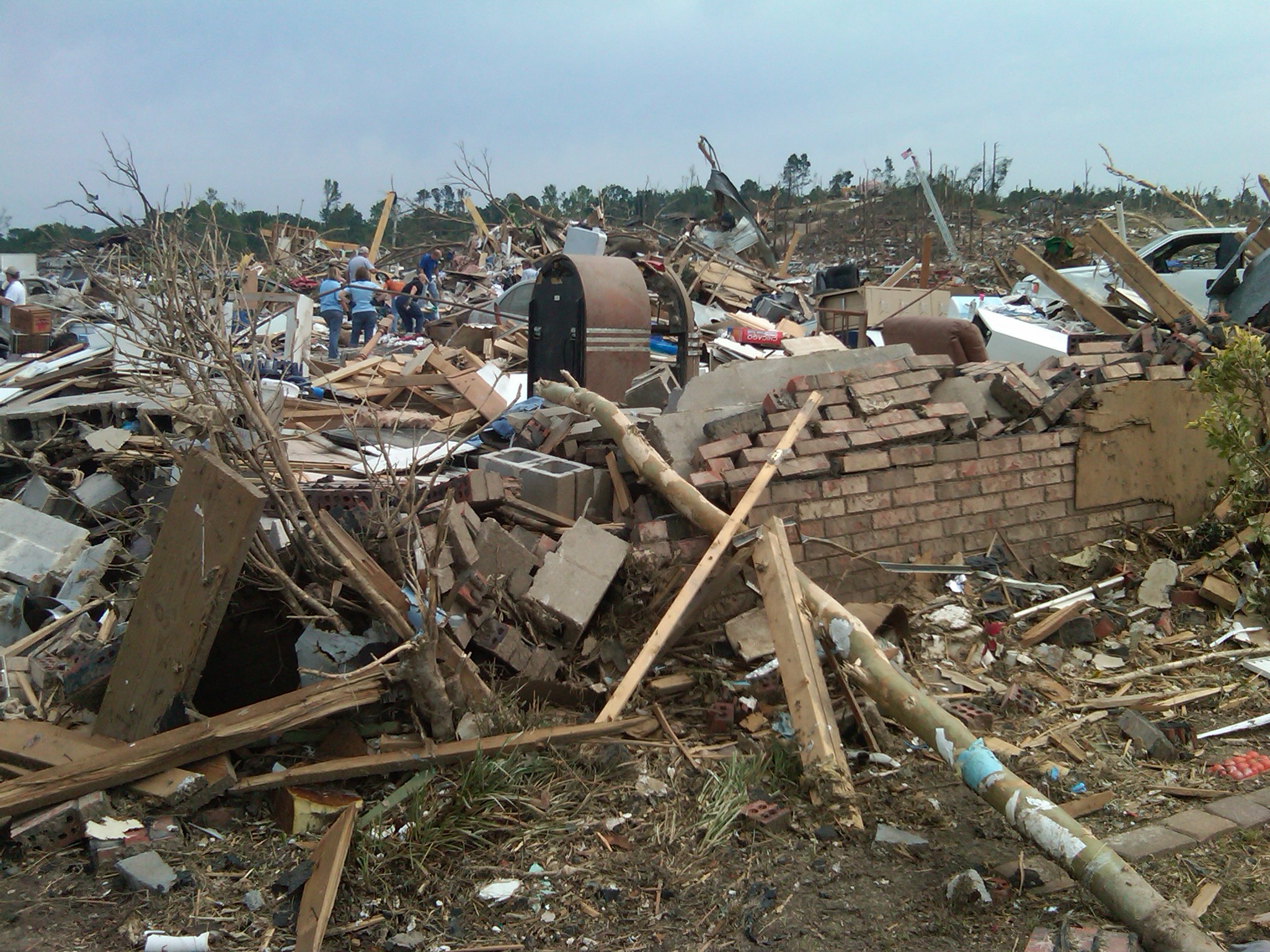
“When I saw a debris field with debris 20,000 feet in the air, I knew, yeah, this was bad,” Roueche said.
The development of the debris field is when the comparisons started. Josh Johnson, chief meteorologist for WSFA, was as emphatic as he could be without shouting.
“I haven’t seen a debris signature like this since April 27, 2011,” Johnson said. “If you are in Beauregard, take cover now.”
Roueche can still see the trees. Some had furniture in the branches that were still in place. Some were snapped in half. Some had mobile homes wrapped around them.
The mile-wide, EF-4 tornado was on the ground for more than half an hour. It took the lives of 20 adults and three children.
Roueche is convinced it shouldn’t have.
“We’ll see catastrophic damage from a tornado and everyone will assume, well, it’s an EF4, it’s an EF5, it’s a super-strong act of God, nothing could have been done,” he said. “But we eliminate the fact that we could be building better. When you start applying engineering principles to it, and start forensically looking at it, it comes down to understanding that the goal isn’t to prevent all damage. That’s not practical. That’s not going to happen, especially in areas that need affordable housing. But what we can do is anchor structures in the ground better than what we’re doing now. I’ve investigated where fatalities occurred and I’ve talked with numerous survivors, and a lot of injuries and fatalities come from when the entire home gets lofted. That’s when things go bad very quickly. That’s what we have to prevent. That’s why we need a better, more accurate characterization of wind behavior to know what loads we need to be resisting.”
So… lights, camera, reconstruction.
“For this new project, we’ll be simulating the debris motion in a controlled environment. We’ll know what the wind speed is, we’ll know what the turbulence is, we’ll know the vertical components of the wind, exactly what debris is flying through the air. We know all those characteristics that we need to ask … ‘how did the debris actually travel?’ and ‘what do our debris flight trajectory models, our numerical models say should happen?’” Roueche said. “That way we can better calibrate the models to a laboratory environment and then put all those pieces together. So, if we see some sort of unclassified flying debris in the field, we can extract type of debris and the trajectories of the debris motion using AI and then use these better, more validated models to infer wind speeds from the trajectory of the debris.”
Would a flying cow count as unstructured debris?
He smiles.
“OK,” he said. “Maybe I should finally just sit down and watch it so I don’t have to turn in my tornado researcher card.”
Pingback: ‘It’s Jordan, like the stadium’: For Georgia fan turned Auburn engineer, the correct pronunciation struggle is very real — and personal